Last check: 07/11/2026 Slap count: 4 Last checked ID: 16777215
21st April 2018 - an update
1
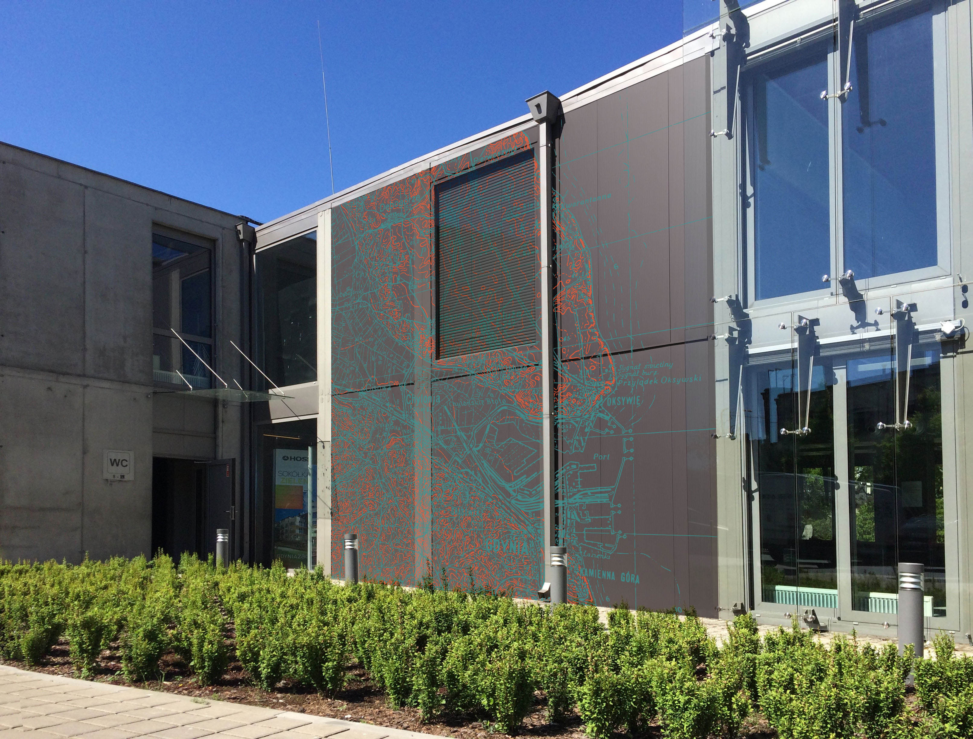
The scans of maps we share are often
used in research papers, internet, or exhibitions. Once in a while
though, you can come across something... unorthodox, such as this application,
found in the Infobox, Gdynia, Poland, by Łukasz Kaczmarek of Pracownia 63A design
studio).
New items:
- from the collection of Mr Ryszard Hubisz: a very large town
plan of Kiew (this time, of German origin, dated 1943). It
is a secret (geheim) variant of the "Sonderausgabe" of the plan
we already have, but the "secret"
variant comes with "enhanced" information, showing additional
buildings, detailed railway infrastructure, etc.
- from the vast collection of the Library of Congress: approx. 500 sheets
of the Soviet 1:25,000 maps dated 1939 - 1940. They are
re-scaled and unrevised reprints of earlier, Tsarist maps, both
half-versts (1:21,000) and verst (1:42,000) editions from the turn of
19th and 20th century. Exact survey dates can be found in top-left
corner and this is how the situation on actual sheets should be dated. The map series covers a large part of the
pre-WW2 area of Eastern Poland (so-called "Kresy", borderlands), but
also Lithuania, and parts of East Prussia.
Since the set in the Library of Congress is the largest collection of
these particular maps we are aware of, we do not expect to be able to
fill in the gaps any time soon. That said, within the next two months,
we will be able to add a relatively large number of sheet to the
German, WW1 set of 1:25,000 maps which cover the same area (and are
based on the same original maps) and extend both east and westwards.
1
The 1st April (no joke! ;), some maps from our own collection -
German 1:200,000 (incomplete) series of:
- Türkei
- Rußland (Kaukasus)
- Rußland (Kaukasus)
- joint editions (Zusammendruecke). Please note, these are large files!
- Rußland (Turkestan)
1
New mapping material from the Library of Congress.
1. Rather detailed German military brochures grouped under the "H.Dv.g
40" (Heeres-Druckvorschriften, geheim), and a full title of "Mil-geo Einzelangaben für die
Trupperführung zum Einheitsblatt...". The publications
contain military and geographic description of terrain for each of the
German, joint edition, 1:100,000 maps, called "Einheitsblatt" (or
"Grossblatt") for the purpose of "troop-leading". Each booklet also
includes a set of 1 - 3 maps. The main sheet is the "enhanced" edition
of the Einheitsblatt, accompanied by other maps, usually printed on the
reverse. They provide an overview of local power grid, gas, soil types,
telecom networks and town plans, often simplified).
We managed to scan several dozen maps and some 12 publications, most of
which cover the area of what was, prior to WW2, eastern provinces of
3rd Reich, and what is now western Poland. Because processing
multi-scan publications takes much longer than maps, we have made
available, for now, all map sheets (other maps for the given sheets are
available as their attachments). We have also processed, as a pdf file
(75 Mb), a samplemil-geo description of sheet 30a
(Einheitsblatt 30a, H.Dv.g 40/30a) from the area of (pre-WW2) "Ostpreussen"
i.e.Rastenburg - Lötzen - Arys, currently Kętrzyn - Giżycko - Orzysz.
By the next few months we will have processed publications for the
Einheitsblatt sheet No 53, 54, 55, 66, 67, 71, 78, 79, 142, 149 and
156. Mil-geo description of other sheets, made available today, can be
expected no sooner than next year.
2. Also, from the collection of the Library of Congress, several town plans,
unfortunately, some are photostat copies, so quality isn't brilliant,
but as they cover smaller towns, they provide useful information.
3. We have added one Soviet town plan of Kiev, courtesy of Mr
Ryszard Hubisz. Although it is called "schematic"
(simplified), it is, in fact, a well-drawn and reasonably detailed
plan, in Ukrainian, made around 1935. Its reliability (accuracy) can be
verified against German, WW2 town plans of Kiev from 1941 and 1943
available here.
15.03.2018_update
In another round of (spring) cleaning, we have added over 300 maps
coming from various university collections, Library of Congress, as
well as our own. Majority of scans show small and mid-scale maps which
often cover vast areas. Please note: as the original maps are usually
very large sheets of paper, 400 and 600 dpi jpg scans often reach and
exceed 100 Mb. Therefore, it is not recommended to try to open files in
web browsers, as they are not optimized to handle high-resolution,
large files, and often come up with a message that this or that image
can not be opened, as it "contains errors". This is usually not
the case; we recommend that you download the files (right-click with
the mouse and "Save as..."), and open them with your preferred graphics
software (irfanview, photoshop, windows photo viewer, etc.)
New literature in Polish, German and English is available, but it will
take some time to translate explanatory notes into English. Hence, as a
temporary measure, new literature can be accessed via the Polish-language
page. All new files are
marked in red. Please note the pdf files can, and do - in
some cases - exceed 100 Mb. We expect to make the updated EN literature
page available by the end of this year.
1
New maps from the collection of the Library of Congress: approx. 700 sheets of the WIG 1:25,000 map,
provisional edition. Current coverage of this map series
(both Polish and WW2 German editions) can be seen on the index sheet. Please note that
the sheets are reprints of earlier maps (Russian and Austro-Hungarian),
often re-scaled, so they show the situation before WW1 or even from the
turn of 19th century - NOT, as suggested by their print date - from
1930s.
1
With kind permission from Mr Jean-Luc Arnaud who runs a digital mapping
project "CartoMundi", we have received
sheets to complement a few series of German Volkstumskarte von Slowakien &
Jugoslawien, byPublikationstelle Wien, from older,
Austro-Hungarian 1:200,000 edition (information about the map-maper,
Wilfried Krallert, can be found in a Wikipedia article, in German).
Please note: you
should find scanned original index sheets (German, Allied, etc.) under
the mapster index sheets and map lists for large map series in mapster.
This should help navigating and establishing full extent of a given map
series.
From the map collection of the Library of Congress, we have added
approx. 800 sheets of the Polish WIG 1:100,000 'tactical map". Most
sheets fill in gaps and provide alternative editions to the
regular-format maps. Majority is from the regular series",
others, were drawn along
different (Russian) sheet lines, showing the areas in the
East). Several German
re-prints dated 1939 and 1940 are interesting as they vary
from the regular German re-prints of this map type available widely in
Poland and elsewhere.
Hey, Marek! Trying to access maps at your page "Other Central European Maps, via both Chrome and Opera browsers, I get the dialog box "File not found (404 error)
If you think what you'r
Hello: I do Polish Genealogy. I need a topo map of Poland with major cities which I’ve never been able to find on the WEB. It should show post partition Poland with an out line of pre-partition Pola
Hi:
Are there any other maps showing parishes such as:
Andrzej Tomczak
Siec parafialna
Wojewoddztwa pomorskiego
Okregu bytowskiego I leborskiego
W drugiej polowie xvi wieku
Skala 1:300.
Thanks


