Last check: 07/16/2026 Slap count: 4 Last checked ID: 16777215
Allied Maps
eAlliedMaps
Introduction Allied mapping
of Central and Eastern Europe closely follows the outbreeak of WW2 and
the “cold war” of 1950s.
Below you will find links to various
British maps by the
Directorate of the Military Survey, formerly GSGS (Geographical Section
General Staff) and American AMS (Army Map
Service), which worked in cooperation to produce war-time mapping at
various
scales. The first stage (1941 - 1943) saw a straight reproduction of
German original maps, with Germany covered by a
litographic copy from the “Grossblatt” type, GSGS 4081 series at
1:100,000 scale. Likewise,
Poland's coverage at 1:100,000 scale (GSGS 4177) and 1:300,000 (GSGS
4172) series was based on reproductions of corresponding Polish pre-WW2
map series. In the second stage, from 1944
onwards, two main
series followed,
based on original sources and aerial photography: 1:100,000
(AMS M641 Germany, M651 Poland and M671 Middle Danube), under common
British ref. “GSGS 4416 Central Europe”, while the 1:300,000 scale was
abandonened to be replaced with various sets of 1:250,000 map, based
around “GSGS
4346 Central Europe”.
In 1943, British mapping service,
together with
WIG cartographers based in Scotland issued a series of 23 “Town Plans
of Poland”, ref. GSGS 4435. Some were based on pre-WW2 Polish 1:25,000
maps, others, reproductions of pre-war tourist town plans (Wilno, Lwow,
Gdynia, Gdansk). This series, as well as two of the easternmost plans
for Germany (Koenigsberg and Breslau), are available here.
AMS
(Army Map Service), Poland 1:100 000, 400 dpi s.
AMS M651 / GSGS 4416 Map series, with
sheet equivalent in size to German Grossblatt / Einheitsblatt maps (and
also 4 x WIG 1:100,000 maps). This series covered Germany, Poland east
to
the area of Grodno, the Baltics (partly), Czechoslovakia, Hugary,
Austria, and Romania (partly). The maps were split into three
groups: “Germany” (M641 and M641S),
“Poland” (M651 and M651S), “Middle Danube” (M671 and M671S), where the
“S” letter stands for the
variant where altitude is depicted by both contour lines and shades of
purple. All those maps series bear common British name of
“GSGS
4416 Central Europe”. Areas of particular interest
(industry, Baltic
coastline) were also updated from aerial photography taken in 1943 and
1944, but only up to (approx.) mid-central Poland. Details can be found
on the bottom right or left margin of individual map sheets. Due to shared responsibilities,
British maps (which
different slightly in the appearance from the US sheets) covered 3rd
Reich, more or less stopping at the current
Polish-German border along the river Odra / Oder; maps further east
were produced by the AMS. Index sheet and available maps`
“GSGS 4346 Central Europe”,
1:250 000
GSGS, 300 and 400 dpi. British
maps
covering Germany, Poland, Czechoslovakia and other countries of Central
and Eastern Europe. Originally series based on German 1:300,000, black
edition of Uebersichtskarte von Mitteleuropa, usually post-1930, and
further east, on Polish and Czech maps in 1:300,000 and 1:200,000
scale, plus other road and railway maps of the area. Index sheet and available maps
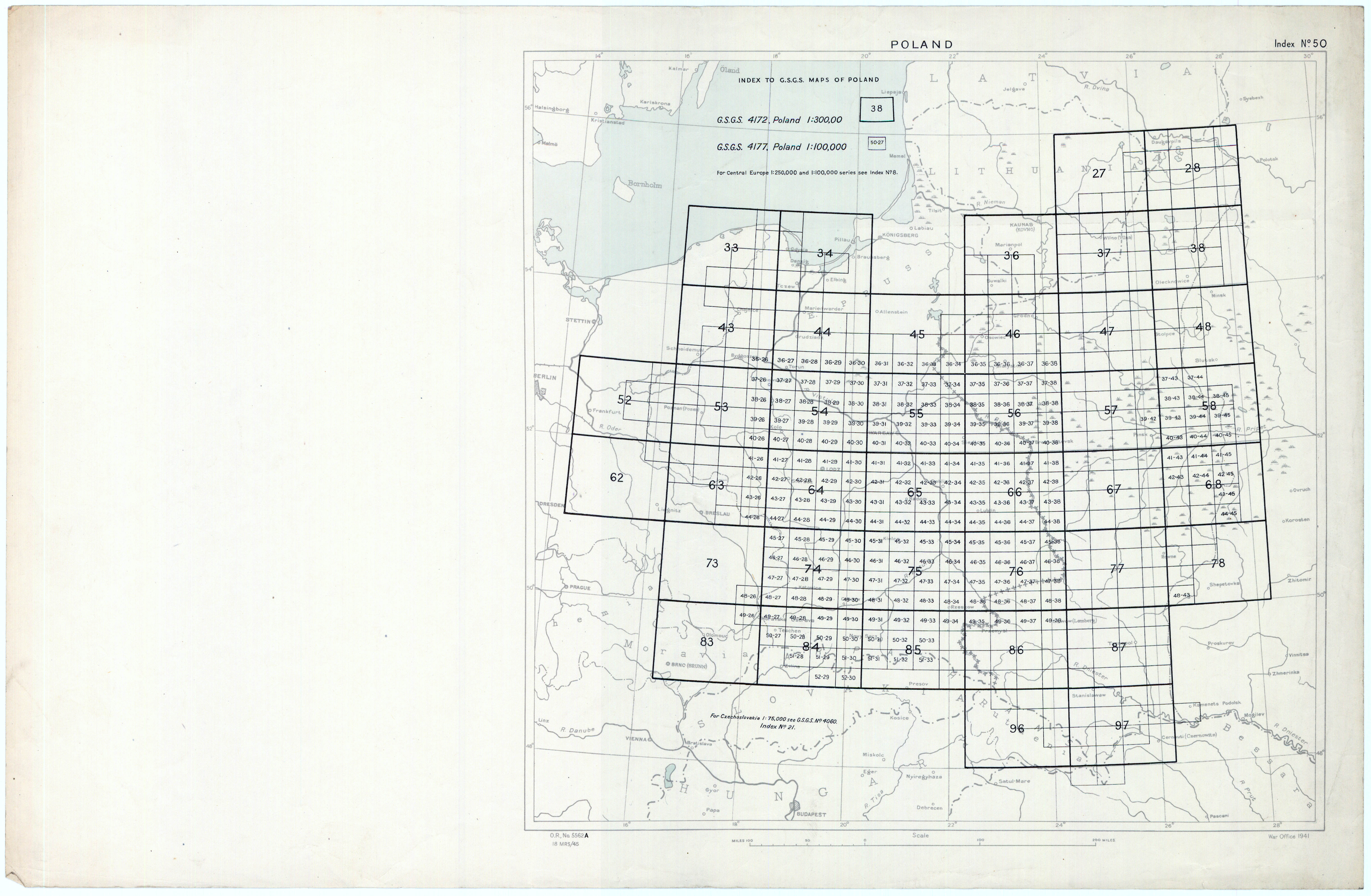
POLAND 1:100 000, GSGS 4177, 1941 (1st
edition) Copies,
some
reproduced in colour by the direct colour separation of the Polish
1:100,000 pre-war series (WIG maps). No revision or British grid. The
set includes a block of
approx. 210 sheets, mainly from Central Poland, and several dozens
sheets (in black-and-white only) covering the area alongside the
pre-1939 Polish-Soviet border (see the index sheet below). This is the
first (and last) edition of this series, superceded in 1944 by GSGS
Central Europe / AMS M671 Poland set, which, however, did go that far
east. +Index
sheet showing the coverage (approx. 2 Mb) (We will be able to present almost
all of the sheets published, by end of 2014)
AMS (Army Map Service), East Prussia 1:50
000 (M752), 400 dpi,
1955-56, Poland 1:50,000 (M751, M753) A map series based on German 1:25,000
Messtischblatt and Topographische Karte, up to 1944. An interesting mix
of old (German) and new (Soviet) place-names, often in US transcription. Another, adjoining set (M751, M753)
continued until mid-1980s, covered
Poland, partly in the pre-WW2 and partly in post-WW2 borders. Currently
all available sheets can be seen and downloaded via this Mapster
index.
Hey, Marek! Trying to access maps at your page "Other Central European Maps, via both Chrome and Opera browsers, I get the dialog box "File not found (404 error)
If you think what you'r
Hello: I do Polish Genealogy. I need a topo map of Poland with major cities which I’ve never been able to find on the WEB. It should show post partition Poland with an out line of pre-partition Pola
Hi:
Are there any other maps showing parishes such as:
Andrzej Tomczak
Siec parafialna
Wojewoddztwa pomorskiego
Okregu bytowskiego I leborskiego
W drugiej polowie xvi wieku
Skala 1:300.
Thanks


