pGermanMaps1919-194526 April 2020:
PLEASE NOTE THIS PAGE WILL NO LONGER BE UPDATED
- All maps mentioned below
(and many more added since this page was updated in 2014) are available
via individual index sheets and map lists in "mapster".
That said, the information below is still valid...
Latest update: 26 April 2020
This page shows German maps, mostly
of Poland and
other Central and Eastern European Countries. The main mapping
organization in Germany was Reichsamt für Landesaufnahme (1921– 1945)
which took over from the Königlich Preußischen Landesaufnahme,
disbanded with the end of World War 1.
Please Note: some files
can be quite large, up to 100 Mb; try NOT to open the scans by clicking
on the link (usually map name) with left button of your mouse. Unless
you have plenty of RAM and a fast processor, you can expect your
Internet Explorer or Firefox to “hang” and a browser is not a good
program for viewing maps anyway. We recommend that you download the
file(s) on the computer first: click on the file with the RIGHT mouse
button and you will see a list of options - then choose “save link
as..”, or “Save target as…”. This will open a window to show where on
your computer to download the file. Once the download is completed, you
can open the file with any graphics / image viewing software,
irfanview, photoshop, global mapper, etc).
Detailed German maps in 1:25,000 scale, so-called “Meßtischblatt”, or
“Topographische Karte” (TK) - from the areas EAST OF current German borders can be downloaded from the Mapster.
As of 2020 we have only a limited selection of sheets covering the
PRESENT-DAY Germany, i.e. WEST OF the river Oder. They can be accessed HERE. Alternatively, look up a large number of Allied sheets dated 1944 - 1960, which cover Germany (within present borders).
The scans below also include maps created or co-made by the following
German bodies:
• OKH/Gen St d. H (Oberkommando des
Heeres / Generalstab des Heeres),
Chef des Kriegskarten- und Vermeßungsgewesens. This army department,
alongside and, sometimes, in cooperation with the Reichsamt für
Landesaufnahme, was responsible for mapping of Poland and other
countries (usually, originally, by 1941, they were referred to as
"special editions" (Sonderausgaben). For the territory of Poland they
were usually copies of
pre-war maps by the Wojskowy Instytut Geograficzny in 1:100,000 scale,
usually, in a joint, 4-sheet edition, identical coverage and numbering,
called Einheitsblatt and Grossblatt - these sheets covered the whole of
Germany, including occupied Poland, Czechoslovakia, Austria and parts
of Hungary.
Another scale was 1:25,000, in various combinations, such as straight
copies of pre-war Polish 1:25,000 maps, blown-up copies of Polish
1:100,000 maps (if original 1:25,000 maps were not available), hybrid
editions, combining the two, as well as new editions based on Polish
materials unreleased by the outbreak of World War. Also, a number
of sheets are also semi-based on pre-1917 Russian maps of Poland,
various scale, from 1:21,000, through 1:42,000 up to 1:84,000 (usually
the contour lines were re-used). In
general, while RfL dealt (at least with the start of World War 2) with
the maps of 3rd Reich and annexed territories for administrative
purposes, Chef des Kriegskarten- und Vermeßungswesens printed maps
for the German armed forces, particularly areas of combat. Those
maps were made from 1940 til 1945.
•
IV Mil.-Geo. (Abteilung für Kriegskarten und Vermeßungswesen), was an
army department with a mission to prepare materials, including general
and detailed maps, town and city plans on the countries which were a
potential, or actual target of attack.
•
Generalstab der Luftwaffe, 7 Abteilung, a mapping unit of the German
Air Force, which used re-printed Polish, Soviet and other maps, with an
overlay of airforce grid, as well as German maps, such as
Übersichtskarte von Mitteleuropa and Osteuropa, etc, as airforce maps..
Other scans are a somewhat accidental
collection of maps, tourist and general, which we have got into our
hands.
The maps are presented according to
scale, although this is not always retained.
Some abbreviations in use:
KdwR
– Karte des westlichen Rußlands (1:100,000), map dated approx.
1890 - 1921, used until WW2, generally based on Russian 1:84,000 scale, mainly for area of Lithuania,
Latvia and Estonia
ÜvM – Übersichtskarte von
Mitteleuropa (1:300,000), as approx. 1942 Eastern coverage of this map type was
re-named "Osteuropa" (OstE)
KDR – Karte des Deutschen Reiches
(Map of the German Reich), 1:100,000
OstE – Ost Europa (1:300,000)
KvM – Karte von Mitteleuropa
(1:500,000)
WK – Weltkarte (1: 1,000,000)
WIG – Wojskowy Instytut Geograficzny,
mapa taktyczna (tactical map, 1:100,000)
KPL – Königlich Preußischen
Landesaufnahme ( - 1918)
RfL – Reichsamt für Landesaufnahme
(1920 - 1945)
Ausg. - (Ausgabe) edition
1:25
000 Topographische Karte (Mestischblatt)
Below
you will find some of the more interesting index sheets for this map
type (eastern sheet) dated 1940 and 1942, and two post-WW2 American
index sheets from 1950s, demonstrating, probably, the easternmost
coverage of this map type. All sheets of this map type, can
be downloaded from Mapster
- please note they're split into 4 index sheets, i.e. Germany East,
Germany (current), and their Allied (AMS and GSGS) equivalents.
| MAP
SETS PUBLISHED BY MIL.-GEO |
1950 |
Army Map Service (AMS) |
A very interesting, post-WW2 American
index sheet of the
German special, military-geographical map editions (Mil.-Geo), produced
by various IV Mil.-Geo sections. The index sheet shows both the sheets
held after the war, as well as those, which had been produced, but were
(at that time) not yet found. |
German photomaps
in 1:25,000 scale (so-called Bildplan and Bildskizze) dated 1937 (?) – 1944
- from the collection of Wydział Nauk Geograficznych
i Geologicznych, Uniwersytet im. A. Mickiewicza in Poznan, Poland,
usually in 600 or 400 dpi.
These photomaps covered the whole of 3rd Reich (within its 1937
borders), probably the whole of western Poland incorporated into
Germany after the 1939 September campaign, an unknown area of central
Poland and - also uknown - coverage of eastern Poland, the so-called
Kresy (borderlands), which are now a part of estern Belarus and western
Ukraine.
For many reasons, a photomap of this type does not match
the clarity of a map of the same scale, but what is crucial is that
such photomap shows - reliably - information as of specific date the
air photos were taken. Nevertheless, you should not expect details
similar to those you can see on google earth.
Most sheets lack
publication date, but they do retain the key element, which is the date
of the air photos takne (bottom left corner of each sheet).
German photomaps, which cover the area of our interest, are cut alongside the sam sheet lines as three map types:
1.
Messtischblatt,
also called “Topographische Karte” – the photomap sheets which cover
eastern sections of III Reich (Pommern, Schlesien) and those areas of
Poland, which, after 1939, was incorporated into III Reich, have the
numbering identical with that of new numbering of Messtischblatt
sheets, and cover exactly the same area (the
link takes you to the appropriate Mapster index sheet)
2.
Maps identified by the WIG 1:100,000 map
numbers (link to the Mapster index sheet).
The sheets were split as per Polish numbering system, e.g. where Polish
"Pas 44 Słup 27 Wieluń" = German "4427 Wielun”. Such sheets were then
split into quarters:
- NW (Nordwest) – north-west
- NO (Nordost) – north-east
- SO (Suedost) – south-east
- SW (Suedwest) – south-west
The sheets of these photomaps are much larger than others, and were -
probably - prepared in 1939 for the imminent invasion of Poland. As the
photos were taken from high altitude, they are not as sharp, despite
high resolution, as other photomaps.
3.
Photomaps with numbering identical with
that of WIG 1:25,000 maps (link to the Mapster index sheet)
The sheets of this photomap type were split as as per Polish WIG
numbering system, e.g. where Polish "Pas 40 - Słup 29 – A Kutno” =
German "4029A Kutno”.
Most of the photomap sheets of this type is dated 1944 and covers some
patches of central / western Poland.
4.
Photomaps from Eastern Poland (Kresy, Borderlands). As we haven't got
any sheets, we can only say that they were divided as per Soviet maps
of that area (the so-called "international system"), and the sheet
numbering was identical to that used after the war in Poland, e.g.
M-34-34-B-c (for 1:25,000 scale sheets). You can see SOME maps of this
type covering the area of Soviet Union.
File size: 10 – 22 Mb.
Other sheets of the photomaps (give or take 2,000 - 3,000) we will get
- hopefully - in 2014 [update as of 2020: the photomaps kept at the US
NARA (National Archives) were moved, in the meantime, to the UK and as
such, they are no longer accessible, unless one is prepared to pay
approx. 60 GBP per scan of each individual sheet). Therefore, we will
try to acquire photomaps from other sources]
|
Three German maps from
the current
Polish-Czech border, probably based on a re-scaled "Grundkarte", German
map in 1:5,000, which was, originally planned to cover the whole area
of Germany. Given the size of the country and the scale of the project
(due to extend to over 140,000 sheets) it's not
suprising it never happened with exception of relatively small, patch
coverage - at least not by 1945. Polish place names in [brackets].
Files 11 – 18
Mb.
Falkenberg
(1926) [Sokolec]
Tuntschendorf
(1926) [Tlumaczów]
Wünschelburg
(1926) [Radków]
A mapping curiosity, a 1:25,000
Ed25 (Deutsches Reich) sheet from central Poland (near Radom). The
content itself is nothing special (re-scaled Polish map known from
original sources), even though, as the source the following was quoted:
“Polnische Karte 1:75 000” (which shouldn't be the case, as these were
1:100,000. And, additionally, on warning, as is the case with such
re-scaled maps, that it is not appropriate for directing artillery
fire).
Sheet numbering is also interesting, i.e. Blatt Nr.
366-D-3, Radom SW, compatible with Grossblatt sheet numberign (No 366
Radom) and the numbering of a new German 1:50,000 map of "former
Poland" (ehem. Polen), with large 50K sheet divided into four: 366 A,
B, C, D, each of which would be, again split into four small 50K
sheets: 1, 2, 3, 4, and each of those would be, eventually, split into
4 sheets of 1:25,000 scale, like this one, marked as NW, NO, SO and SW.
Maps with such numbering were produced - most probably - only for a
small area of central Poland (Radom, etc). The south section of the map
borders on the "regular" 1:25,000 numbering taken from Polish WIG maps,
e.g. "4432A" (original Polish "Pas 44 Słup 32 A") and "4432B" (Polish
Pas 44 Słup 32 B).
It is probably the last edition of this sheet, dated January 1945:
Deutsches
Reich 1:25 000 Blatt Nr. 366-D-3 Radom SW (approx. 12 Mb)
Other,
earlier sheets of this map type, dated from approx. 1939 - 1944, can be
seen in Mapster via this link.
German Map (Deutsche Karte),
scale 1:50 000.
(link to the index sheet and
several sheets available in Mapster)
This map type was to replace an already outdated (and not too clear,
given the haschures) Map of
the German Reich (Karte des deutschen Reiches) in 1:100,000 scale, but
as the introduction dragged on, it was never done on a large scale,
with the exception of southern
Germany, where in Bavaria it had been introduced much earlier. The
1:50,000 scale sheets from 1930s cover mainly the area of Berlin. Also,
approx. 30 - 50 sheets from the area of Lower Oder river (currently in
Poland) and Pommern (Pomorze). Small, test sheets were printed approx.
1927/1928, while full size ones in 1937 - 1939.
Some sheets are lost (or presumed lost). Others are kept in libraries
which charge dearly for scanning and making them available, such as the
British Library.
1:50 000 map
of the Polish occupied territories, so called “Deutsche Reich, ehem.
Polen”
(link to the few sheets in
Mapster).
Very
little is known about this map type and very few sheets are available
in libraries or private collections. Other than the scale, this map
type, has
nothing to do with the abovementioned Deutsche Karte (or any other
1:50,000 German map of Eastern Europe, other than the scale).. Accoding
to the
information from mid-1944 (Planheft ehem. Polnisches Raum, Juli 1944):
"There
are plans to make a map suitable for directing artillery fire for the
front troops. Regular sheet of an Ed50 map covers ¼ of a Grossblatt
Ed100 sheet. However, due to the need to provide maps faster, the
regular Ed50 sheet also has to be divided into four smaller sheets.
Therefore, a Grossblatt Ed100 sheet is made up of 4 regular 1:50,000
(Ed50) sheets or 16 x small 1:50,000 sheets."
As the front-line moved west, plans to extend the coverage in
south-eastern and eastern Poland (Kresy, Borderlands) were naturally
abandoned, but as the front stopped alongside Vistular river in January
1945, by that time, a number of (small) sheets for this map type were
produced. All the sheets we managed to scan from the collection of the
Library of Congress, USA, and a couple of other, loose sheets, are
accessible through the mapster INDEX.
Ed50 numbering structure:
Regular
sheet will have the same numbering as Grossblatt sheets, and they will,
additionally come with an extra letter, from A to D, e.g. "375B"
Small
sheet will have the same numbering as Grossblatt sheets, and the A to D
letters will be followed by a number from 1 to 4, e.g. "375B-3"
(...)”
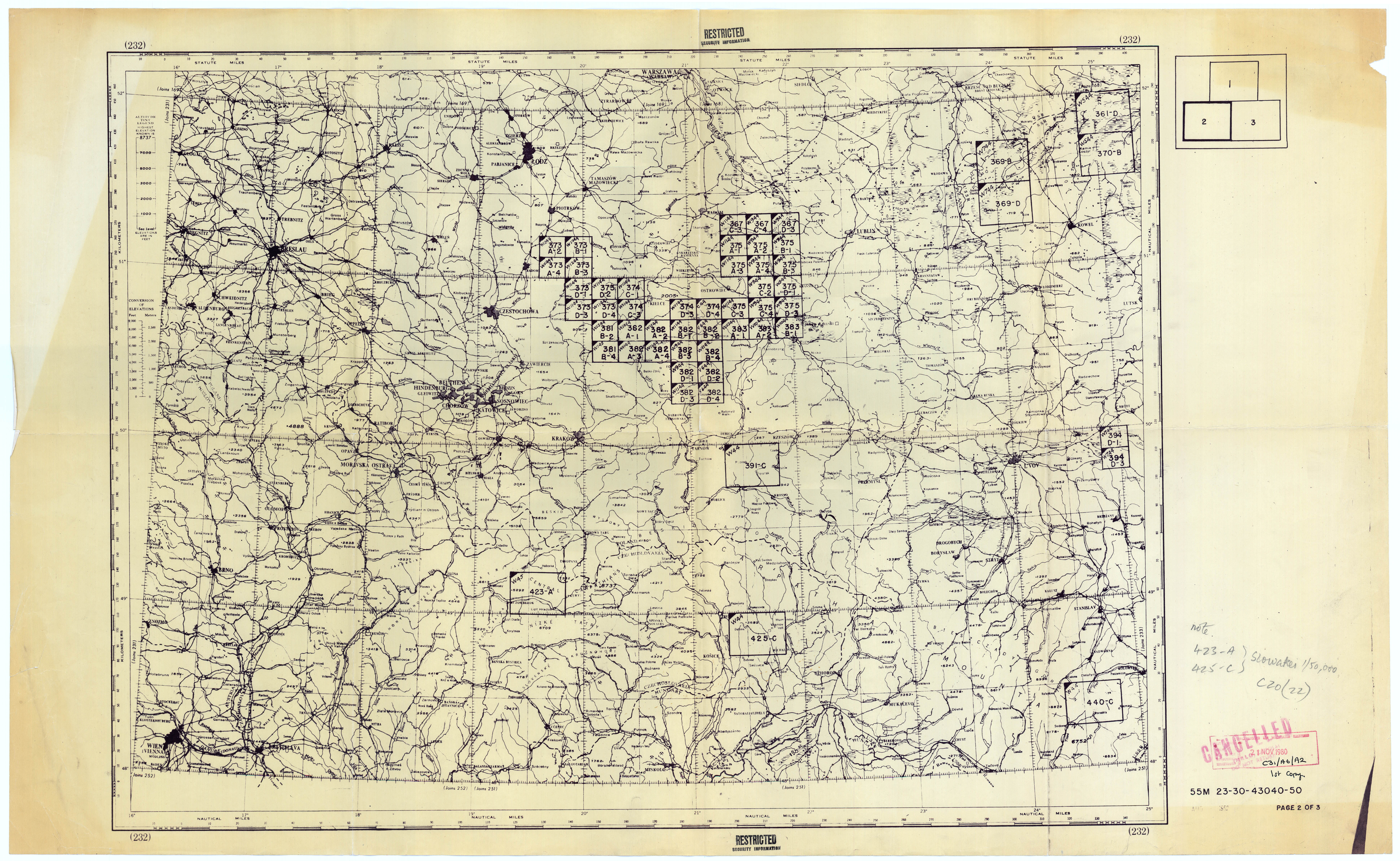
According
the the American index sheets from 1950s (available below), between
February and December 1944, around 50 small and several large sheets of
this map type were made, scattered over a very large area of central
Europe, from Polesie (Polesia) in Belarus, through central Poland and
Czechoslovakia, with a few odd sheets elsewhere. The maps were based on
various sources, e.g. re-scaled 1:100,000 Polish WIG maps from 1930s,
Polish 1:25,000 maps, unpublished, pre-war WIG survey materials and
German air-photos from 1944.
Post-war index sheets:
| Sheet title: |
Size (MB) |
DPI |
Publisher |
Comments |
INDEX
TO MAPS OF POLAND
DEUTSCHES REICH 1:50,000 1 of 3 |
4.8 |
200 |
Army Map Service
(AMS), approx. 1951 |
Digits in the top left corner of each
sheet indicate the month and year this particular sheet was made.
This index sheet shows the (small) coverage of this map east of Brest
until Dawidgródek (Davyd-Haradok), in Belarus. |
INDEX
TO MAPS OF POLAND
DEUTSCHES REICH 1:50,000 2 of 3 |
4.6 |
200 |
Army Map Service
(AMS), approx. 1951 |
This
index sheets shows the bulk coverage of this map type in central Poland
(Częstochowa – Radom – Lublin i Tarnowem) and single sheets from
Czechoslovakia and the Ukraine (near Worochta / Vorokhta). |
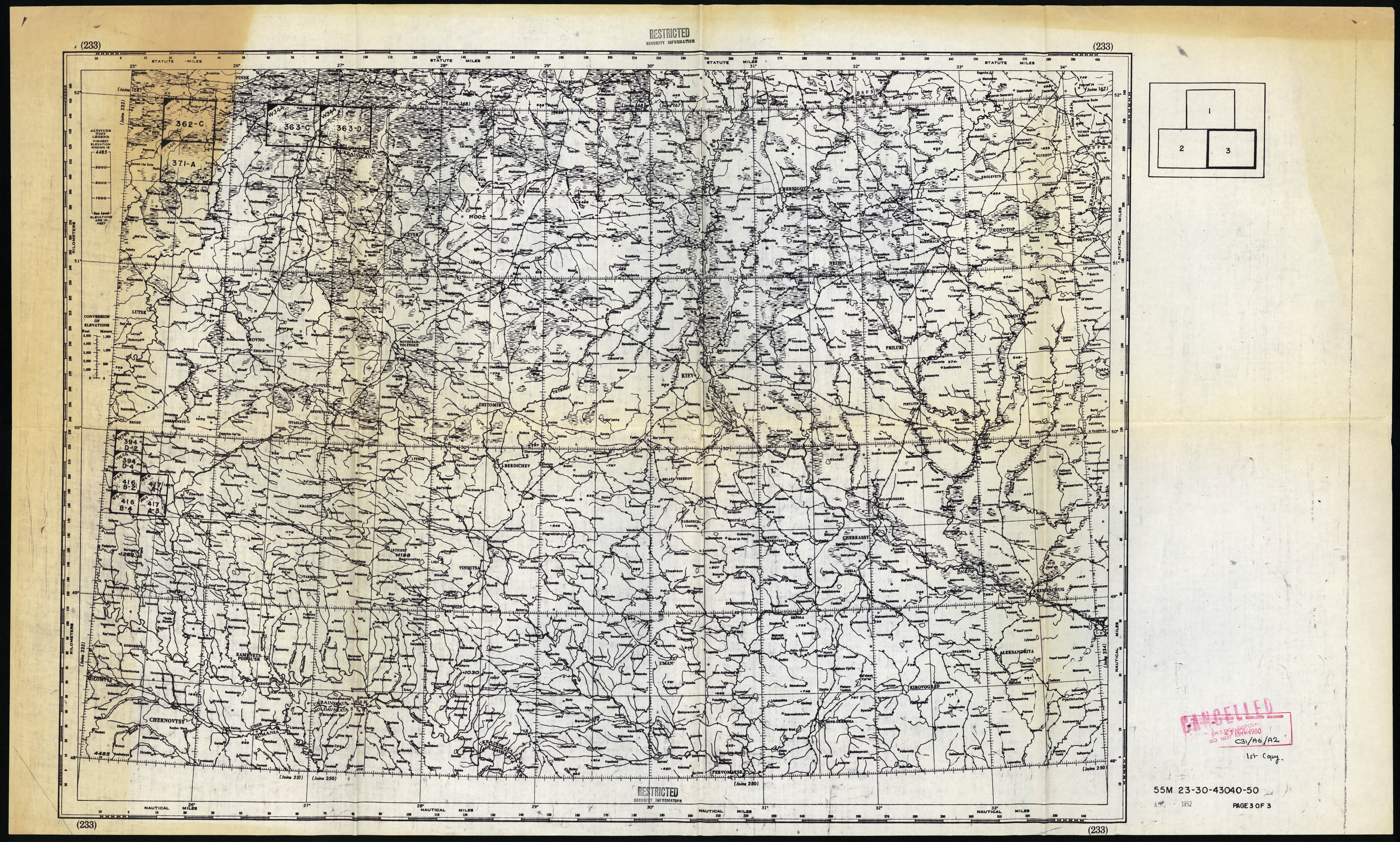
INDEX
TO MAPS OF POLAND
DEUTSCHES REICH 1:50,000 3 of 3 |
5.1 |
200 |
Army Map Service
(AMS), approx. 1951 |
This index sheet shows a fringe coverage
in Belarus and some in the Ukraine (several regular and some small
sheets). |
|
|
|
|
|
| Availability
of Deutsches Reich (Gen. Gouv.) 1:50,000 |
|
200 |
Directorate of
Military Survey (GSGS) |
Index
of the British Directorate of Military Survey, covers the sheets (both
originals and copies) held in the library of the British military
cartographic servce in 1950s. They follow the US index sheets (no
discrepancies with exception of regular and small sheets being marked
on the same sheet), but it shows interesting information about
"materials" for some new sheets of this map type from the area of
Warsaw, which probably never made it into new maps.
As of 2020, no 1:50,000 sheets of this map type have been found in any UK libraries.
|
Karte des Deutschen Reiches, tzw.
„Generalstabskarte” 1:100 000
The
most popular German map, in the 4-sheet editions known as
"Einheitsblatt” or "Großblatt”. These maps were produced by the
Reichsamt fuer Landesaufnahme and, during WW2, also by the cartographic
detachements of Wehrmacht. Therefore, most sheets exist in a large
number of editions and reprints, easily exceeding 20, on top of which,
a large number of sheets were also produced, with extra information
overprinted on them, as special editions, e.g. "Panzerkarte", or
"Mil.-Geokarte". "Maps of the neigbouring countries" and those conqured
by the III Reich were simple copies, and sometimes, re-worked editions
of the maps produced by those very countries, e.g. Polish, Czech or
Soviet maps.
All editions we have managed to
gather by now, are available via Mapster index sheet.
Below the index sheet in mapster, you will find numerous, original index sheets with coverage.
"Kreiskarten”
and "Umgebungskarten”, scale 1:100,000
Based on the "Karte des Deutschen
Reiches”, with added administrative borders and tourist information
(youth hostels).
The sheets available in Mapster, alongside original index sheets (below the mapster index):
Kreiskarten
Umgebungskarten
Sonderkarten
(including a few "special" maps, such as two sheets from the East
Prussia, made by a locally-stationed printing unit, or a map of the
"Mitte" training ground)
Manöverkarten
(maps produced for specific units participating in manouvers)
German maps
of the USSR (1940 - 1944), "Russland 1:50 000" and "Russland
1:100 000"
based on Soviet maps.
A cheerful quote from a person who had a chance to take a good look at a large
collection of those maps: "There is no end to the German maps of this
type. There are individual sheets. Sheets joined - in twos, fours,
sometimes three in a row. Or large, 9-sheet sets. Some are
straight, reprinted copies of Soviet originals. Others include
corrections or updated, e.g. overprinted place-names. Some are updated
from intelligence reports, others from air photos, some are fully
re-drawn…"
Please note that the index sheets, while mostly empty, cover VAST areas
of European Soviet Union, therefore they take a long time to load.
Single sheets of
"Russland 1:50 000" in Mapster
Joint sheets of "Russland 1:50 000" in Mapster
Single sheets of "Russland 1:100 000" in Mapster
Joint sheets of "Russland 1:100 000" in Mapster
Topografische Übersichtskarte des Deutsches Reiches 1:200,000
The
map which was intended to replace the "Uebersichtskarte von
Mitteleuropa" in 1:300,000. It didn't happen by 1945, and the two maps
co-existed, with the 1:300,000 type vastly more popular and used. Only
in 1943, the 1:300,000 map got a fresh look, while the until the
1:200,000 edition was abandoned, due to strained resources, some time
towards the end of 1943. It was revived and successfully developed,
after the war, in West Germany as , well, Topografische Übersichtskarte
(TÜK200).
However, all original, prepared sheets and even plates, have been
collected in Germany (although it is not known for certain which
institution holds them. Possibly Bundesarchiv).
All scans of this maps are
available in Mapster, most sheets available in 400 dpi.
1:300,000 Übersichtskarte
von Mittleuropa
Map type produced in 1919 - 1945, scale
1:300,000, continued development of pre-WW1 "Übersichtskarte von
Mittleuropa".
Early sheets, such as Frankfurt, Königsberg are straight reprints of
the Königlich Preußischen Landesaufnahme editions from before World War
1. From mid-1930s, Polish 1:300,000 were used (copied), and during WW2,
captured Soviet maps in 1:100,000 and 1:200,000 scale were used to
produce new editions of the German map. Approx. in 1942, a subset was
creaated, called “Osteuropa”, followed by “Mitteleuropa” and “Europa”.
Apart from a sheer number of sheets, which stretched from Western
Europe to Moscow, their editions and updated, there were also variants
with overprinted fortifications (Befestigungskarte),
military-geographical editions (Mil.-Geokarte), road editions
(Reichs-Autokarte) and a large number of sheets were also produced as
the so-called Fliegerausgabe (Airman edition) with overprinted air grid
(Luftwaffe Meldenetz, Lw.M.N. A smaller number of air editions came
with a grid for fighter pilots (Jägergradnetz).
All
sheets currently available in Mapster (Please note, it's a VERY large
index sheet, so it loads very, VERY slowly!)
(joint
edition of this map type dated 1939 - 1945 are also available in
Mapster).
A single sheet, which does not conform to the regular 1:300,000 sheet
lines:
Straßenzustandkarte
3G
It is possible the sheet was drawn in the process of
border delimination in 1939/40, when Germany occupied western and
central, and Soviet Union eastern part of Poland (the area around Łomża)
Another odd 1:300,000 sheet, this time dated spring 1945, from the area of occupied Czechoslovakia (Strassenkarte)
Many other interesting 1:300,000 maps can be found on mapster
(including two, 1944/45 Lagenkarten, joint and updated front-line
editions (Please note, files are over 40 Mb each):
Lagekarte Nr 48 (Zusammendrueck Warschau)
Lagekarte Nr 51 (Kolberg - Stettin)
German
1:500,000 map
All sheets available in Mapster
Übersichtskarte von Europa und Vorderasien 1:800,000
Prior
to WW1 it was referred to as "Operationskarte”. This map type was
discontinued and replaced, in mid-1930s, by 1: 1,000,000 (1 milion) map.
Sheets of this map type available
in Mapster
WK
– Weltkarte (1: 1,000,000 mln), sometimes also referred to as the "DWK"
(Deutsche Weltkarte)
Sheets of
this map available in Mapster
German administrative and other
maps (rail and road maps, post maps, etc.), from the times of WW2., available in Mapster
Tourist
maps, mainly from the mountain areas of (then) east Germany,e.g.
Riesengebirge / Karkonosze, Eulegebirge / G. Sowie, etc., by
various private publishers - available in Mapster.
|


